Translate Global Addresses to Precise Geo-Coordinates
Our Address Geocode – International service enhances risk assessment and shipping logistics by delivering more than just an address. It offers precise rooftop longitude and latitude coordinates globally, ensuring pinpoint accuracy for any location worldwide.
Address Geocode – International is an integral component of our product suite, designed to elevate the precision of your location data. It works by cross-referencing your provided addresses with authoritative global data sets, resulting in the delivery of highly accurate rooftop-level geo-coordinates for nearly any location worldwide.
This service encompasses two key features:
Geo-location: This functionality converts any global address into its corresponding latitude and longitude coordinates, expressed in decimal degrees. It’s an essential tool for mapping and spatial analysis.
Reverse Geo-location: Inversely, this feature takes latitude and longitude coordinates and accurately translates them back into a detailed address, formatted according to the specific postal conventions of the relevant country.
Together, these features ensure comprehensive and precise geo-spatial data handling for various applications, from logistics to analytics.
24/7/365
Customer Support
99.999%
Uptime Guarantee
Dedicated
Support Engineers
Features and Benefits of
Address Geocode – International
Enables Accurate Pick-up and Delivery
Address Geocode – International leverages our 20 years of address expertise to provide powerful and accurate results in real-time throughout the world.
Both addresses and geo-coordinates are cross-validated using a combination of authoritative postal and spatial data
Advanced artificial intelligence maximizes match rates and accuracy in any country
Flexible outputs allow you to meet each country’s postal addressing conventions
Returns Additional Location Intelligence
Depending upon the sophistication of the country’s authoritative sources, Geocode – International provides supplemental information including:
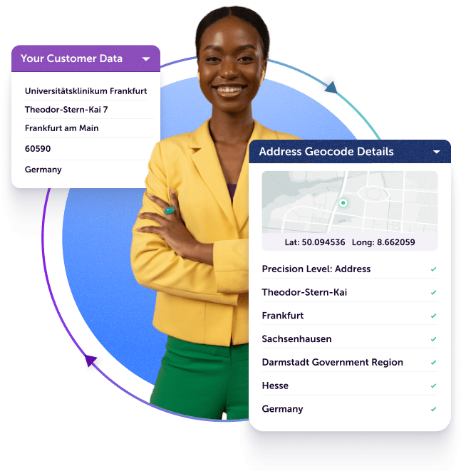
Returns 16 levels of precision including points of interest (POI)
Also returns locality, administrative area, postcode and country
Enables point-to-point distance calculations commonly used for shipping logistics and insurance risk assessment
Provides custom mapping URLs for popular mapping tools
How Address Geocode – International Works
Returns Geo-Coordinates from Input Address
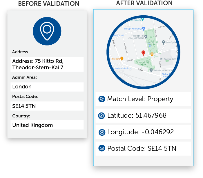
Addresses are corrected and standardized using Service Objects Address Validation, then converted to latitude and longitude coordinates.
Supports Reverse Geo-Coding to Address
Latitude and longitude coordinates are translated to validated and precise addresses in proper country format.
Cascading Logic Delivers Highest Resolution
Returns 16 levels of precision including points of interest (POI), and also returns locality, administrative area, postcode and country.
Creates URLs for Google Maps
Creates and returns Google Maps URLs for mapping applications.
For a deeper dive into all of our APIs, visit our developer guides. If you’re ready to put it to the test, sign up for a free API trial key and get 500 free transactions.
We use cookies to enhance your browsing experience.
Cookies, tracking pixels, and similar tech are small data files served by our platform and stored on your device. They help with site operation, personalization, and may track your usage for targeted ads on other sites.
By using our site, you agree to our cookie use.
Third-party services may also deploy cookies, including Google, Facebook, and others. These services collect anonymous data like IP addresses and device IDs for analytics and site functionality.