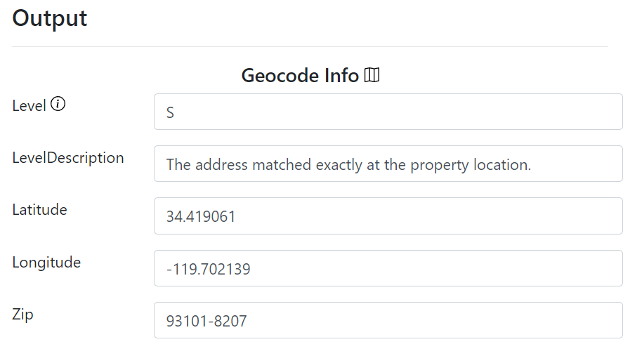
Level: A code indicating the resolution level at which the address matched. The codes are:
- S – Street Level Property Match
- P – ZIP plus four match
- R – ZIP plus three-match
- T – ZIP plus two match
- N – ZIP plus one match
- Z – ZIP level match (ZIP plus zero)
- C – City/state match
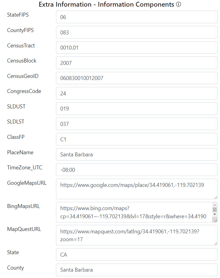
StateFIPS: Federal Information Processing Standard code. FIPS codes are numbers that uniquely identify geographic areas. The number of digits in FIPS codes vary depending on the level of geography. State-level FIPS codes have two digits.
CountyFIPS: Used to uniquely identify counties across the US. County-level FIPS codes have five digits, of which the first two are the StateFIPS code.
CensusTract: The census tract of the given address. A census tract is a statistical subdivision of a county. Census tracts are small, relatively permanent statistical subdivisions of a county. They are uniquely numbered in each county with a numeric code. The CensusTract will be a 6-digit decimal number.
CensusBlock: A block is the smallest geographic unit used by the US Census. Census blocks are grouped into block groups, which are grouped into census tracts. The CensusBlock will be a 4-digit number.
CensusGeoID: GeoIDs are numeric codes that uniquely identify all administrative/legal and statistical geographic areas for which the Census Bureau tabulates data. The value will be a 15-digit number comprised of the StateFIPS + CountyFIPS + CensusTract + CensusBlock.
ClassFP: A code that defines the current class of the geographic location. See a more detailed description of the current list of ClassFP codes below.
CongressCode: The congressional district number.
SLDUST: Current state legislative district upper (Senate) chamber code.
SLDLST: Current state legislative district lower (House) chamber code
PlaceName: The name of the place that the coordinates are associated with. Most commonly this is the name of a municipality, city, town, village, or community. Some addresses will have an alternate PlaceName that is different from the input. For example: Ventura, CA can be identified as San Buenaventura, CA.
IsUnincorporated: Indicates if the coordinates are for an unincorporated area. This only appears for street-level property matches (S).
- Indicates that the coordinates fall within the boundaries of a known unincorporated area.
- Indicates that the coordinates fall outside of the boundaries of a known area.
TimeZone_UTC: The time zone in UTC offset format.
| ClassFP Code | Class Code Description | Associated Geographic Entity |
| C1 | An active incorporated place that does not serve as a county subdivision equivalent | Economic Census Place, Incorporated Place |
| C2 | An active incorporated place that is legally coextensive with a county subdivision but treated as independent of any county subdivision | County Subdivision, Economic Census Place, Incorporated Place |
| C3 | Consolidated City | Consolidated City |
| C4 | Alternate official common name for an incorporated place | Locality Point |
| C5 | An active incorporated place that is independent of any county subdivision and serves as a county subdivision equivalent | County Subdivision, Economic Census Place, Incorporated Place |
| C6 | An active incorporated place that partially is independent of any county subdivision and serves as a county subdivision equivalent, or partially coextensive with a county subdivision but treated as independent of any county subdivision | Incorporated Place |
| C7 | An incorporated place that is independent of any county | County or Equivalent Feature, County Subdivision, Economic Census Place, Incorporated Place |
| C8 | The balance of a consolidated city excluding the separately incorporated place(s) within that consolidated government | Economic Census Place, Incorporated Place |
| C9 | An inactive or nonfunctioning incorporated place | Economic Census Place, Incorporated Place |
| M1 | A military or other defense installation that is not entirely within a census designated place | Locality Point, Military Installation |
| M2 | A military or other defense installation entirely within a place | Census Designated Place, Economic Census Place, Military Installation |
| U1 | A census designated place with an official federally recognized name | Census Designated Place, Economic Census Place |
| U2 | A census designated place without an official federally recognized name | Census Designated Place, Economic Census Place |