
What can a little latitude and longitude do for your marketing? A great deal, as it turns out.
For starters, geotargeting – or the use of geographic coordinates to define your target market – has been shown to double the performance of many marketing campaigns, according to statistics from the Local Search Association. Moreover, it opens up a wide range of other attractive data-driven strategies.
In this article, we will look at how you can use geocoding to supercharge your own marketing efforts.
Why ZIP codes aren’t enough
People often target their marketing efforts using the address data currently in their contact database, particularly by ZIP code. A wide variety of demographic information is available at the ZIP code level, and if you’ve ever watched Beverly Hills 90210, you know that they can serve as market indicators. However, the problem is that in many cases they are much too coarse a criterion.
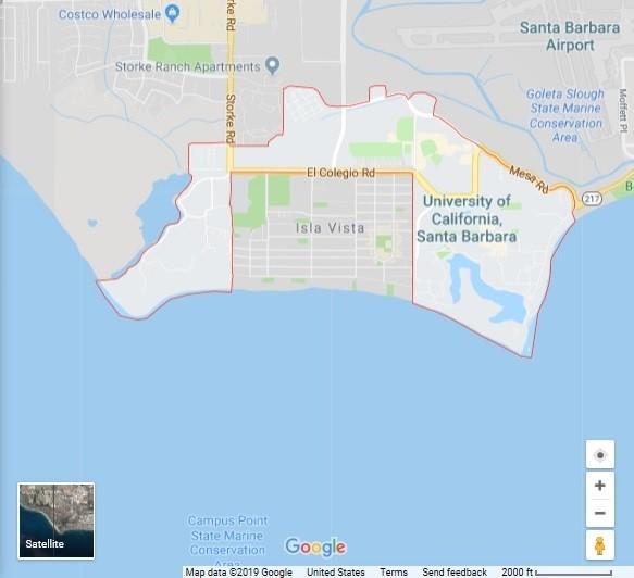
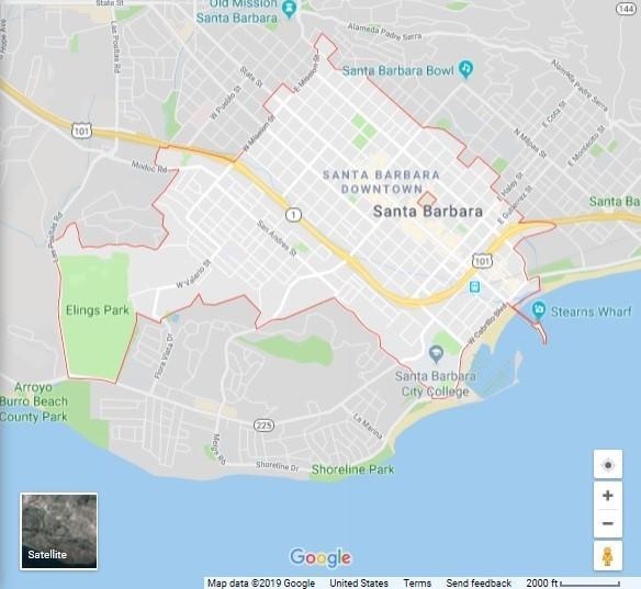
In our native Santa Barbara, California, for example, the demographics of a particular ZIP code vary widely. First, let’s take ZIP code 93106. You might be correct in assuming it has a fairly young and intelligent demographic because this entire ZIP code belongs to the University of California at Santa Barbara. Move a little further east toward downtown Santa Barbara and ZIP code 93101, however, and it is a different story: its neighborhoods range from posh oceanfront villas to low-income housing.
This is why one increasingly popular strategy known as opt-out geotargeting involves using geolocation coordinates to exclude less likely prospects from a contact data sample such as a ZIP code, versus traditional opt-in marketing of specific areas. Either way, whether you are marketing to working people or the wealthy, geolocation and demographics together can help you gain a laser focus on the most likely ROI for your marketing efforts.
Other applications of geocoding
There are many applications for geocoding data beyond lead identification, particularly when you leverage this data against the demographics of precise areas. Here are just a few:
Targeted messaging. Geography is often one of the most important calling cards for a prospect or customer: for example, one neighborhood may be family-oriented, while another one blocks away may be an enclave of hipsters. Mapping areas based on demographics or neighborhood characteristics helps you design more appropriate messaging for your products or services.
Location-based personalization. Here businesses tailor merchandise, services or offers to consumers living in specific geographic locations. Or vice-versa: according to Fortune Magazine and others, the use of business-based geotargeting is exploding rapidly, as consumers increasingly broadcast their movements via mobile devices and applications.
For example, a recent Geospatial World article describes a promotion by Pepsi in India where pictures of 100 popular food items were put on its bottles, and consumers could text a code to get nearby deals on these foods (which presumably paired well with a cold Pepsi). Here, geospatial information about businesses drove a marketing strategy.
Distance-based marketing. It doesn’t make a lot of sense to target offers to consumers who would have to fight two hours of traffic to get to your store. Geolocation provides an easy way to calculate distances between customers and bricks-and-mortar establishments, to rapidly target service areas and likely markets.
Business intelligence. Geocoding data allows you to perform data analysis for a specific market or region, to help you to make better business and marketing decisions in the longer term – for example, adjusting your mix of products or services, your marketing approach, or seasonal promotions. And with the aid of tools such as a geographic information system (GIS), you can explore this data visually as well as numerically.
How we can help with geocoding
Service Objects offers two convenient tools for adding the power of geocoding to your contact database. Our DOTS Address Geocode products for the US and Canada are real-time geocoding APIs that will turn your address data into latitude and longitude coordinates. Our US geocoding service also provides census tract, county codes (FIPS), block codes and more, as well as reverse geocoding capabilities that can take latitude and longitude values and return an estimated address.
For targeted marketing or compliance applications, our DOTS Address Insight – US combines address validation, geocoding and demographic data in one convenient real-time service, designed for API integration with your marketing automation or CRM platform.
For more information about either of these services or to try them out using 500 free transactions, visit our website using the links above.